At a Glance
- Florence is now intensifying and has regained hurricane strength.
- Rapid intensification into a major hurricane is possible by Monday.
- A strike on the U.S. East Coast is increasingly likely.
- This may happen as soon as Thursday.
Those near the East Coast should monitor closely and firm up their hurricane plans.
Florence is generating swells that are beginning to affect parts of the U.S. coastline.
Florence has strengthened back into a hurricane and is forecast to rapidly intensify and could pose a serious danger for the U.S. East Coast where a direct strike is increasingly likely by mid- to late week.
If you are near the U.S. East Coast, develop or review your hurricane preparedness plan and be ready to implement it if necessary.
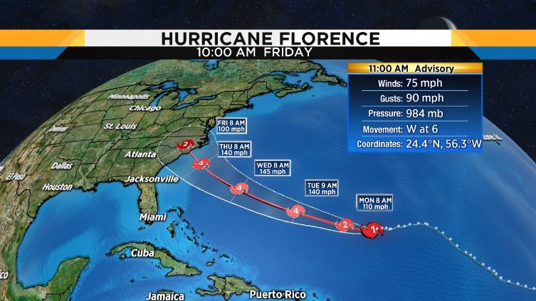
As of Sunday morning, Florence was still more than 700 miles southeast of Bermuda, moving due west.
Where Florence turns north around the western periphery of that high-pressure system will determine what part of the coastline experiences the worst wind and storm surge impacts. It's important to note that flooding from heavy rain could be a major concern in a much larger area that extends farther inland, potentially including parts of the Carolinas and the mid-Atlantic.
The National Hurricane Center is forecasting Florence to be a major hurricane (Category 3 or stronger) when it makes its closest approach to the Southeast later this week.
Here is what we know right now when it comes to Florence's potential impacts in the U.S. Keep in mind all of this is subject to change in the days ahead, so check back for updates.
Timing: The peak impacts from Florence are expected to arrive on Thursday but this could trend earlier or later. According to the NHC, Thursday is the most likely timing for tropical storm-force winds to arrive on the Southeast coast. Impacts from Florence, particularly heavy rain, may continue into next weekend if it stalls out for a time as suggested by some forecast guidance.
Locations Potentially Affected: Areas from southeast Virginia to the Carolinas are most likely to see the first impacts from Florence. As mentioned earlier, it's too early to nail down specific impacts for this stretch of coastline. Also, this could change depending on future forecast trends for Florence's track. For this reason, locations farther south such as Georgia and northern Florida and farther north into the mid-Atlantic should also monitor Florence for any forecast changes.
Coastal Impact: Large, battering waves in combination with rising water from storm surge could cause destructive impacts along a part of the coastline near where Florence strikes. Significant beach erosion is also likely on the Southeast coast.
Wind Impact: Numerous downed trees and long-lasting power outages could occur near and inland from where the center of Florence strikes. This threat of tree damage and power outages may also extend across Florence's larger swath of tropical-storm-force winds. Structural damage to homes and buildings is possible, particularly where the core of any hurricane-force winds move through.
Rainfall Impact: Florence could not only produce heavy rain along the coast but also farther inland across the Carolinas and mid-Atlantic. That heavy rain threat may last for days if Florence stalls out into next weekend as suggested by some forecast guidance. If that stall occurs, disastrous flooding could occur in some areas. See the link below for more information.
By weather.com meteorology team
Comments
Post a Comment